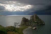
Olkhon Island
more about this picture >>
Photo: Vjatscheslaw Petuchin
With 72km in length and approx. 10km in width, the sunny Olkhon Island is the biggest island in Lake Baikal. The island is settled by the Buryats and its name "Olkhon" comes from their language. The real meaning of this name is not known, but sometimes "Olkhon" is translated with "little forest" or with "dry". Both translations might be true, the landscape of the island is very lovely. The north is dominated by coniferous forests in contrast to the south, where you'll predominantly find hilly country of the Tageran Steppe.
The Western shore shallowly ends in the "small sea" and that is the place where most of the settlements are situated as well as the capital Chuzir. The Eastern shore consists of steep rock faces that even continue in the water. Just some kilometers away from the Eastern shore is Lake Baikal's deepest point with some 1637m.