Hiking the the Markovo (1870m)

Starting point of the minimally two-day route is ideally Glinka, a former holiday area with a pool. Ever since a fire (short-circuit, says someone...) in the 90ies it has been completely abandoned with the exception of a caretaker. You get there, coming from the mainland, by following the division of the street not to Manachovo and/or Kurbulik, but towards the south, along the stony east coast from Swjatoi Nos.
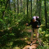
The path (tropa) starts directly behind the house in Glinka, the caretaker calls it "hotel", and runs at a distance of approx. 300 m parallel to the shhore. After 200-300 meters the path turns left towards the west at a wooden table and at a sign saying "Natshalo Tropui". This is the beginning of the hiking path and you are led to the west into the close forest and toward the mountain. The beginning is just walking. With no considerable upward gradient, you won´t miss the path because it is well-trodden.
After approximately half an hour to 40 min. an old, half rotten sign is attached at a tree, saying "rise 50%". A worn-out hiker wrote "Tui horosho podumal?" (have you considered well?) on the side of it. >From here follows a tidy piece of work with your backpack on. Approx. 3 hours of steepest rise, first seamed by pine and birken forests, later over rubble and bushes to the first pre-peak, where you have made it through about half of the elevation meters. From here you already have a fantastic view on the land connection of Swjatoi Nos and the Baikal lake. You continue on in a blocked area.
After a further hour of going up you might be disappointed at first, because a "genuine" summit can hardly be found. Rather, a large plateau spreads out in front of the hiker. In early autumn, however, the bushes turn in to a great sea of red and yellow. The real summit of the Markovo is northeast of the plateau. Nearby the summit, there is a spring and some small ponds. This means you can limit your water supplies for the up-hike. To pitch your tent you will find many opportunities. There are even several spots set up for bivouacs with a cooking spot.
The view - if it is there - can only be called simply terrific: from the northwestern edge of the plateau you can see the Ushkani archipelago, the opposite shore of the lake and the approx. 50-60 kilometer-away island of Olchon in the south. Towards the east, you get a wonderful view of the land tongue and the extending marsh areas, while as well you can see the bays of the Tshiwirkuyski area and throw a a glace in the north into the Barguzin mountains and the Northern Baikal.
For the descent there are two possibilities we recommend on the eastern side. On the one hand, you can take the ascent route back in approx. 2-3 hours, on the other hand there is a route following the mountain ridge to the southeast and back to the shore. For the latter one, you had better plan a further day of staying out, however.