Frolikha Adventure Costline Track (F.A.C.T.)

The Frolikha Adventure Coastline Track (F.A.C.T.) leads you through one of the most beautiful, unspoiled and rugged scenery at Lake Baikal. At the north shore, there are still no streets, no villages and apart from the sanatorium in Khakussy also no tourist infrastructure. Already at the arrival via Baikal-Amur-Magistrale (BAM) to Severobaikalsk, THE central starting point for all activities at the northern Baikal, you get an impression of the vast extent of Siberia and the loneliness of the taiga. Hikers on the F.A.C.T. should be aware of this situation and prepare themselves adequately in advance. First and foremost, good gear is essential, in particular sturdy shoes, food supply for up to ten days, an extensive first aid kit and especially experience of how to behave and orientate oneself in the wilderness! If an accident occurs, help is far away and you depend on the random encounters with rangers, fi shermen or hunters. Only at some of the few exposed spots of the hike you may have mobile reception.
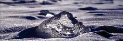
The trail almost always leads you along the partly sandy and often stony shore of Lake Baikal or on narrow paths through the forest. Time and again you have to cross up to 65 m wide rivers or overcome quite big lumps of rock. You cannot rely on any aids such as bridges or ladders.
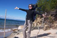
F.A.C.T. Impressions - picture 1 of 21 >>
Siberian summers are generally warm and sunny, but unfortunately very short, which is why you should be prepared for night frost and short snow showers already in August. You should also reckon with suddenly gathering storms and heavy rain, which is not dramatic on the shore, but can delay the way back by boat by hours or days. Especially in June you should keep an eye on ticks, which can generally be found often in Siberia, and examine one another for the unpleasant teases.
Furthermore you should bring a good mosquito repellent, as these animals can become a terrible nuisance during windless days. Last but not least almost the entire track leads you through protected nature reserves, i. e. you are only allowed to use driftwood lying around for a campfire, and taking back the litter should be a natural course of action.
F.A.C.T. - The first long distance trail of Northern Lake Baikal - a short description from North to South:
A joint project of Baikaplan e.V and MOO Bolshaja Baikalskaja Tropa
Starting point - the ranger station
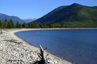
The long distance trail is about 100km long and starts from the ranger station of the Verkhne Angara Nature Reserve, follows endless sandy beaches, rests in real bay paradises, climbs steep cliff lines, makes a loop to the Frolikha lake from its deepest bay called Ayaya (the "very, very beautiful bay") and ends in the relaxing atmosphere of the hot springs in Khakussy. Mostly the trail exactly follows the coastline, but some parts also lead deep into the Taiga forests or test your bouldering qualities.
Frolikha - the river which gave the name to the trail
Halfway through and after crossing some smaller creeks now and then, you will soon face the (deep) delta of the Frolikha river, which stretches about 65m from one to the other end. Embedded in huge marshes, your only choice will be to cross the river. The easiest way to do that is surely by a small (inflatable) boat you carry with you, even more thrilling - and moreover a "weight watcher's" delight - is to built a raft. However you manage this part, don't forget a rope to get back your means of transport - currency is not very strong, but also nothing to be sneezed at.
Ayaya Bay (the "very, very beautiful bay")

Next of the highlights is the deepest and coldest bay at Lake Baikal. To get there, you must cope with the most difficult part of the entire trail. Bouldering across huge ragged rocks directly above, sometimes almost in the lake, you will need sure footedness, concentration, time and patience. In exchange you will soon get to one of the most beautiful places at Lake Baikal with a most impressive panorama, a wonderful sandy beach and the chance to make a detour to Lake Frolikha, which is (at least) a 5km-hike into the mountains. This lake is not only renowned for its unique position amidst beautiful scenery, but also for its endemic biodiversity. Some species to be found have not changed since the ice age, e.g. the Davatshan fish.
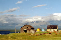
The hot springs of Khakussy

The last stage of the tour will not only lead you to the most beautiful and cosy camping-site of the trail, but first of all to the hot springs of Khakussy, which is a place with some small huts and lodges. Is there some better place to rest after 100km hiking adventure, but in hot springs? Even beer is served to cool down after an exhausting hike. Not yet tired from hiking? No problem: You will either have the chance to visit the caves of Cape Khaman Kit, or the "singing dunes" of Cape Turali, or the small Evenk settlement even further in the South. Getting back to Severobaikalsk is no problem during summer season: You will simply take the regular boat between Khakussy and Nishne-Angarsk.
F.A.C.T. - supported by:
|
Hewlett-Packard GmbH Link |
Intercomp Global Services Link |